- Thumbnail
- Resource ID
- 23fc56d6-906d-11ea-ae3c-06760a0009eb
- Title
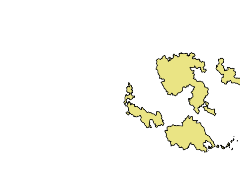
- Pilot Areas Borders
- Date
- Jan. 1, 2018, 7 a.m., Publication
- Abstract
- Spatial data representing the coverage of Pilot Areas subject of the WetMainAreas INTERREG BalkanMed project.
- Edition
- --
- Owner
- University_of_Forestry
- Point of Contact
- Purpose
- --
- Maintenance Frequency
- unknown
- Type
- vector
- Restrictions
- otherRestrictions
- No conditions apply for access. For use: You are free to share, copy and redistribute the material in any medium or format under the following terms: a) give appropriate credit using the reference: University of Forestry. 2019. Geospatial dataset: Wetlands of Bulgaria. WetMainAreas INTERREG BalkanMed project; b) non commerical; c) no derivatives; d) no additional restrictions. For more details please refer to the Creative Commons Attribution 4.0 International license (CC BY-SA 4.0) https://creativecommons.org/licenses/by-nc-nd/4.0/.
- License
- Not Specified
- Language
- eng
- Temporal Extent
- Start
- --
- End
- --
- Supplemental Information
- No information provided
- Data Quality
- The responsible organization for the quality of the data is University of Forestry, Bulgaria.
- Extent
-
- long min: 5110175.000000000000000
- long max: 5622700.000000000000000
- lat min: 1853125.000000000000000
- lat max: 2216050.000000000000000
- Spatial Reference System Identifier
- EPSG:3035
- Keywords
- no keywords
- Category
- Environment
- Regions
-
Europe
,
Bulgaria
,
Greece
,
Macedonia